Today we went to see Monument Valley. There are 17 miles of red dirt road that are accessible to everyone. This is the scenic loop. We elected to drive through on our own instead of taking a tour. The forces of nature that formed these mesas, buttes, and spires are difficult to fathom. The story of these rock formations began 570 million years ago. This entire area was covered by the Gulf of Mexico. In the intervening years the Rocky Mountains erupted and through eons of erosion, wind, water, ice, and volcanic activity, the land was shaped and reshaped. What remains is called Monument Valley. We spent our morning standing in awe of these ENORMOUS rock sculptures. We took lots of pictures of rocks!
We left Monument Valley.
We crossed the San Juan River.
We followed 163 to the town
of Mexican Hat. This is Mexican Hat
Rock.
We took 261 onto Valley of the Gods Road.
Lunch spot.
Beautiful day…another beautiful day…we are surrounded each day by beautiful nature and we cannot get enough…who knows where we will end up tomorrow!?!
Our first order of business today was to go to Cortez and shop for supplies, post the blog, and Tim needed a haircut. Did you know that you could get a haircut at Walmart? That is one of the very hard things about this gypsy life we lead…where do you go to get your hair done? We tried in the last two towns and there definitely was nothing for me. We will have to wait until we stay somewhere for awhile so that I can schedule something!
After Cortez, there were big expanses of open terrain, rocky and desert like. We were down to 5,000 feet of elevation!
Route 160 is NOT a designated scenic route…but what a pretty ride.
We had to stop at Four Corners Monument. This is the only place in the United States where you can stand in four states at the same time. This monument is on Navajo tribal land. Vendors had all kind of jewelry and other trinkets for sale.
The remainder of our ride was a series of incredible views. The monoliths and buttes rise up out of the earth and surprise you as you pass by.
Morefield Campground Mesa
Verde National Park, Mesa Verde, Colorado
Our tours of the cliff dwellings
at Mesa Verde were scheduled for today.
The first tour was at Cliff Palace and began at 11 am. It took the better part of an hour to get from
our campground to the site. Much of the
mesa has been affected by wildfires usually as a result of a lightning strike.
The Cliff Palace tour begins
with a descent of 100 feet on a combination of metal stairs and carved
sandstone steps. There were a series of
five 10-foot ladders to get into and out of the site. Our tour guide, Ranger Brown, began with a
safety talk. It sounded like it might be
hard but I really wanted to go and I was determined to climb the ladders!
A small portion of this
community was constructed in AD 200.
Most of the community though was built 1,000 years later around AD
1200. The Cliff Palace consists of 150
rooms and 23 kivas.
This pueblo has a seep spring
that provided water. There were several
others nearby within 3 miles of the site.
The presence of water is one reason that this area was chosen. The top of the mesa was farmed. The people were able to grow beans, corn, and
squash. These vegetables were
supplemented with wild game and potatoes that were grown on the canyon
floor. The shelter was made of stone
hand cut with a stone hammer and a stone axe.
The mortar was made of soil, sand, ash from the fires, and water. Chinks were placed in the mortar to keep it
from seeping out from between the joints.
Roofs were supported by 8-inch Utah juniper trees sections. It is estimated that using a stone ax, the laborer
had to strike the tree 100-300 times at each end. The igneous stone used for the tools was gathered
in the distant San Juan Mountains. The
walls were fairly plumb and many of the corners were 90 degrees. Tim could tell where different masons had
worked to construct the shelter. I was
amazed by the resilience and perseverance of these people.
We traveled a short distance to
Balcony House for the 1 pm tour. This
site has 38 rooms and 2 kivas. We were met by Ranger David. Ranger David also gave a safety talk. This tour is the most strenuous at Mesa
Verde. There was a 32-foot ladder to
ascend into the balcony and then narrow passages to crawl through. The small tunnel was 15 inches wide and 27
inches tall. At the end, there were two
10-foot ladders and a steep uphill climb on narrow stone cut steps. As Ranger David spoke about the serious risks
of this tour and the 18 rope rescues that the rangers had done in the past year,
I got anxious. I wasn’t sure that I could
do it. He encouraged everyone to walk as
far as the 32 foot ladder and then decide for themselves if they should
continue. I verbalized my doubt to Tim
who told me that I could do it! I had
done Cliff Palace fairly easily after all!
I am so glad that Tim nudged me to step outside my comfort zone and try
it!
The first stop was a small pool of holy water. This water gathers under the rock from a spring and from rainfall and snow melt. This water is significant to native peoples who still return here to gather water for ceremonies.
The 32 foot ladder…
Ranger David was
remarkable. His passion for this place
is unparalleled. He grew up in the town
of Mancos nearby and as a child he had decided he wanted to be a ranger at Mesa
Verde. He was raised by and English
mother and a Native father. He learned
very early in life that when people talk about religion is makes more sense to
focus on the verbs and not the nouns. He
stated that wars were fought over nouns but if we focus on the respecting,
treating others with kindness, hoping, and loving, then we all have those
things in common. He wanted us to leave
Mesa Verde reflecting on what makes us all human and what people share.
We passed through this narrow
passage that opened to the balcony.
Ranger David spoke about the
importance of water and food and shelter in this dry and hostile
environment. He spoke about the function
of the kiva as a place for ritual and community meetings. The kiva is a circular room partially
underground. Each kiva has a ventilation
shaft, a firepit, a ladder into the kiva from the roof, and a sipapu. The sipapu is a small round hole in the floor
of the kiva. Ranger David told the story
of the sipapu. This is the place where
the native people believe that tribal ancestors emerged into the world. Ranger David went on to talk about the real
importance of the kiva, every bit as important as water, food, and shelter is the
sense of community and love and hope that exists here. Hope for food, hope for rain, and hope for
forgiveness…
These are milling
stones. These are a cause of early death
for many of the people in the community.
The stones they used were sandstone and as they ground the corn, silica
was released into the air causing lung and breathing problems. Sandstone is soft and as the corn was ground,
so was the stone. The stone particles
became part of the food, eroding tooth enamel and rotting teeth. Rotten teeth were an easy way for infection
to enter the body. The life expectancy
for women was 25-35 years old. Men lived
to be 35-40 years old. I am sure that
women’s life expectancy was affected by their job as corn millers and the risks
of childbirth.
The way up and out of the cliff dwellings was steep and difficult.
We drove the rest of the park road, stopping to see distant views of other cliff dwellings.
I am so grateful for the opportunity to see this remarkable place and I hope to bring my grandchildren to this park one day!
Morefield Campground Mesa
Verde National Park, Mesa Verde, Colorado
Today was Sunday. It was moving day. We filled with water, emptied our tanks and we were on our way to Mesa Verde. We decided not to take Highway 550 after all. GPS wanted us to take 62 to 145. This is the San Juan Skyway. We drove up and out of the valley and away from the ranches. This was a picturesque drive. The character of the mountains changed with the rise and fall of the road.
There were lovely lakes and
mountain streams at ear popping altitudes over 10,000 feet. There was a persistent nip in the air and the
sky was thick with clouds.
The leaves are changing quickly. We will probably be in Utah when the leaves
peak in Colorado!
We passed tiny towns,
fishermen in their waders fly-fishing, hawks soaring and lots of deer.
As we approached Mesa Verde,
the landscape changed yet again.
We ate lunch and went for a ride to see the park. We began at the visitor center. Mesa Verde National Park is dedicated to the preservation of the Ancestral Pueblo people. Mesa Verde was their home for over 750 years. There are nearly 5,000 archaeological sites here. 600 of those are cliff dwellings. We purchased tickets for two tours tomorrow. This is the only way we can actually access the cliff dwellings.
We are staying in the Morefield Campground.
The views of the Montezuma
Valley are unbelievable. It was hard to
stop taking pictures…and then it was hard to chose my favorites.
This is a fire lookout station. Every day, all day from May until the end of September, someone sits in this lookout scanning for wildfires.
Our first glimpse of cliff dwellings.
Today, we drove to Wetherill Mesa. By the time we arrived, our options for exploring were time limited. The walking trail to Step House was already closed for the day. There was a paved multi-use path, so we hopped on our bikes. We went to the Badger House Community ruins where we learned a little bit about how the earliest inhabitants of this area lived. In AD 1 the Ancestral Pueblo people were semi-nomadic. By AD 550 the people began to farm on the tops of the mesa. The soil there was fertile and the people devised ways to collect water. This is when the first pithouses were built.
By AD 750 the people lived in
single-story villages.
As time passed, the building techniques became more advanced. The people began to fashion rectangular brick from the stone and they made a crude cement to hold the bricks in place.
Just walking through these age-old
remains is awe inspiring. What a
difficult life these families had.
In AD 1100 multi story villages were designed and then in AD 1200 cliff dwellings were utilized. By AD 1300 the thousands of people that lived here had migrated. As with every ancient story…there is a lot of conjecture to fill in all the parts of the story that are not understood. I cannot wait until tomorrow to learn more.
Agave plant with fruit.
We saw a group of 4 large bucks as we entered the campground this evening.
We began the day at the
Ridway State Park. We biked to the
reservoir and then along the river. It
was 75 degrees and the sky was a cloudless blue. The ride was flat and effortless. Biking here in this peaceful place made us
both feel serene and calm.
Canadian goose.
California gulls…we think…
Our rodent of the day.
I saw this sign. Although the sign is weather-beaten and worn,
I love the message…We cannot live without wild things!!
Next, we chose to go to the Owl
Creek Pass. The beginning of the ride
took us through ranch land.
It’s so dusty here, I usually feel like Pigpen at the end of the day!
Fortunately it was Saturday…so no road work!
Ranches gradually gave way to forest and saw-tooth mountains.
Random stacks of boulders along the road. Tim swears that someone with a machine must have moved them.
Owl Creek Pass was at an
elevation of 10,114 feet.
Open range sheep…hundreds of
them!
9 miles further took us to
Silver Jack Reservoir where we had our lunch.
Food eaten outside always tastes better to me. We had BLT’s with the fresh bread and produce
we bought at the farmer’s market yesterday.
Since it is our last night in Ouray, we decided to go out for dinner.
We ate at The Outlaw. This was a western saloon compete with a piano player.
A huge ggma pour…the bartender didn’t want to leave the last couple of inches in the bottle…
We have stayed here for a
week. That’s a long time for us to stay
in one place…but we have enjoyed each and every day. Each trail that we have
taken, each town that we have wandered through has had its own special flair. It’s time to move on now. Tomorrow, we have reservations in a campground
at Mesa Verde National Park. We cannot
wait to see what adventure awaits us there.
Today we took the Jeep with
our bikes north to Ridgway. This was a
nice place to cycle, another neat mountain town.
We stumbled upon a farmer’s
market and bought some apples, heirloom tomatoes, greens, and fresh country
bread from the Blue Grouse Bread Company.
We found the riverside bike
path and enjoyed the perfect weather as we pedaled along.
The path runs along the Uncompahgre River.
Those hills though…we were at
an altitude of 7,000 feet. This does not
usually bother us at all…but with exertion…we were gasping for air…no worries
though…I just got off and pushed the bike up the hill!
The Dennis Weaver Memorial
Park was lovely.
This eagle sculpture weighs
2,800 pounds and the eagle has a wingspan of more than 20 feet. It is part of a prayer garden where visitors
are encouraged to build their own cairns.
I love outdoor musical instruments and can never resist the opportunity to play as I walk by…such joy!! It makes me feel like a little girl! This is a metallophone.
The Ridgway Railroad Museum has the mission of restoring and preserving old train cars and providing education. Karl is a volunteer. He spent a long time telling us the stories of the railroads of the San Juan Mountains. He was very gracious and extremely knowledgeable!
This is a 1937 CAT. It was used for clearing mudslides and snow to make the railway passable.
All of the train cars here have been or are in the process of being lovingly restored.
This is a stock car used for transporting cattle or sheep. Apparently, sheep don’t like to get on train cars. They used two trained goats to lead the sheep onto the train. The goats received the reward of chewing tobacco for their hard work.
We found Gnarly Tacos for our
lunch, great food and tart lemonade.
We took Tim’s bike into the shop for new brakes and I went into Mountain Market for some groceries.
This evening I walked over to fence to look for deer in the field. I heard something falling from the tree.
I saw a small squirrel sitting on a tree branch.
He finished his pine cone and dropped the core. He chittered at me and fled.
Last evening, we borrowed the
DVD, A Walk In The Woods, from the camp store.
We have seen this movie before.
Nick Nolte and Robert Redford go for a walk on the Appalachian Trail. This movie is funny and wry and poignant. It resonates with us and the choices we have
made and we enjoyed seeing it again!
It was 35 degrees overnight and 47 when we started today’s journey. We saw this old Willys at the gas station.
We took the “Million Dollar
Highway” or 550 to Ironton Park. The
Million Dollar Highway might be named because it cost a million dollars to
build it, or because the fill dirt for the roadbed contains a million dollars
in gold dust, or because of the breathtaking views…no one is really sure!
Check out these hard core cyclists!!! No guardrails, lots of tight turns, RV’s and semis, soft soulder…
Frost on the ground…
We did another part of the Alpine
Loop, the Corkscrew Gulch.
This Jeep is clearly outfitted to navigate this road in a bunch of snow!
This was an easy and pleasant
ride. We spent the morning sightseeing
and bebopping to the music of the 60’s.
As we climbed more of the
mountains was revealed to us as you can see in this series of pictures. They are Red Mountain #1 and Red Mountain #2.
The pass is in the tundra at 12,047 feet. There we saw a pair of military jets careening between the peaks.
In the distance we could see this
snow filled ring of mountains.
As we descended into Silverton, this was our view.
We strolled along Main Street looking in shops as we passed.
We found the Pickle Barrel
Restaurant for our lunch.
We returned to the RV early and I spent the afternoon doing laundry and other chores.
As I returned to our campsite, I saw these 4 Class A RV’s each with a Jeep parked in front…done for the day. What we do might seem unusual but I promise there are lots of other people out here enjoying these trails with us!
We went for a sunset ride this evening.
There are three elk here on the hillside, visible only with our excellent binoculars.
We have decided to stay in
Ouray a bit longer. In order to stay at
the campground we are in, we needed to change sites.
We were still on our way by 9
this morning. The plan today was to do a
portion of the Alpine Loop. To travel
the entire trail is more than 100 miles.
We thought about going half the distance and staying in a hotel
overnight in Lake City. The hotels were
around 200.00 a night. I would rather
spend that money on other fun things!
The ride today was rocky and steep from the very beginning. There was a Chevy Blazer 2 cars in front of us. He was stuck and we waited for him to figure his way out with the help of his friend. We found out that it was only the second time he had ever driven off-road and he was “kinda nervous.” Adding to his difficulty was that he was driving a manual transmission. Tim told him to take his time and go slow. We stayed a distance back so that he wouldn’t feel pressured and just hung around with him at a much slower pace than normal…just in case he got into trouble. There were lots of difficult rock maneuvers.
The attrition rate on the
trail was high from the get go. One Jeep
turned around and headed downhill after a radiator leak. A Cadillac Escalade had also turned around…probably
realizing quickly that his vehicle was not suited for the trail.
The sky was grey and then we
had some rain showers making the trail just a little slippery.
We passed yet again more
avalanche sites. The trees really do
provide insulation for the snow beneath.
In may areas the snow was several feet thick.
Today was more technically challenging and less lovely.
I started to pay attention to the changing leaves and then I began to look for rainbows as the sun popped in and out. I then really started to look for beauty in the smaller details. I saw moss and lichen growing on rocks.
Rain droplets on leaves and
branches.
Scarlet red berries.
Tiny yellow alpine flowers.
Sporadic purple asters.
Rushing streams.
Tiny fir trees making their
way into the world.
A mining shack.
As we ascended the tree line,
in the alpine tundra, we were treated to fantastic vistas.
We caught a marmot sunning himself on a rock. I took about a dozen pictures…I only saved one…or two…
We stopped for a late morning snack…apparently, I was getting a little hangry.
We drove through a deep snowbank. This was the result of a significant avalanche. You could still smell the scent of pine from all of the splintered trees. There were branches and tree trunks haphazardly mixed in the snow. What combination of elements caused these trees to come tumbling down the mountainside? Melting snow, the weight of new snow, high winds, the bald mountaintops? These roads are only open for a couple of months each year.
We drove into the town of Silverton. There is a neat historic Main Street with restaurants and shops. Today there was an organized road trip with a bunch of classic cars. The town was bustling!
We stopped for lunch at the
Gold Block Brewery and had a salad and a delicious buffalo chicken pizza.
We took highway 550 back to Ouray. When we got back it was nap time! Then blog time. Then dinner time. Our days pass so quickly!
We started the day by taking
care of some business. Of course, we packed a picnic and then headed out. We started on route 550. This is a narrow road with steep drop-offs and
no guardrails. We wanted to see if we
might be able to drive here with the RV later this week. We want to go to the town of Durango and 550
is the road to take. Tractor trailers
use this road and we think that when the time comes, we can too!
We took the road to Ophir
Pass.
At the highest elevation, we
were at 11,789 feet. This mountaintop
was above the tree line and it was a very ragged and an inhospitable environment.
As we mounted the pass, there was a tremendous view on the other side. The steep way down the mountain was a rocky shelf only wide enough for one vehicle at a time. We waited at the top as a line of Jeeps and motorcycles made their way up.
We made our way into the tiny
town of Ophir.
There is a lot of recent
avalanche damage high on all of the mountains.
Last year, this area had a higher than usual amount of snow.
We drove to the town of
Telluride. This is an upscale ski resort
town.
We found the Telluride Town
Park for our lunchtime picnic.
Magpie.
Today was not a day to see
the town…we were on our way to the next mountain trail, Imogene Pass.
The guidebook we are using rates this as a difficult trail. It also states that the “views are reserved for the adventurous few.” It is the second highest pass in Colorado…and one of the “most thrilling!” This is not a trail to be taken lightly. We had to use extreme care with vehicles approaching from the other direction.
As we climbed the mountain,
we could see the zigzag trail that is the Black Bear Pass.
We left Telluride and the ski
trails far below.
The aspen trees are just
starting to turn golden at the higher altitudes. We could see falling leaves glinting in the
sunlight as they floated from the trees.
The Tomboy Mining town has
been long abandoned. The are shacks,
sheds, shafts, equipment, tailings, twisted metal, and timber all left behind.
Loveliness…
As we travel these trails, if
we see someone stopped, we stop to check on them…it’s what you do out here…you
pull over and ask if help is needed.
Today, there was a guy on a motorcycle that had wiped out on the incline to Ophir’s Pass. He and his partner were debating whether they should move forward or retreat. Another man on a motorcycle became short of breath and lightheaded near the top of Imogene Pass. His friend was walking him back down the trail. It’s important to have the right machine to ride here. We saw a man driving a Land Cruiser. As he went down a difficult and steep set of rocks, we heard the grating sound of metal scraping rock…not so good. With our short wheel base and larger and lifted tires, we were slowly and safely making our way! Tim carefully navigated the boulders strewn in our path…quite like picking his way through a minefield. The book calls it driver’s choice…the driver has to choose between the better of two evils.
Imogene Pass 13,114 feet…as high as we have been…unbelievable…so pretty!
Check out this snowbank!
The way down.
Yes this is the road!!!
We also met a
hiker/runner. He was running to Ouray
from Telluride…he was amazing!!! He
actually beat us down the mountain…we had to go so slowly. When we passed him close to Ouray…5 or 6
miles later, Tim stopped and told him he was a “badass man!” The runner thanked him and just kept on running!
Imogene Pass was a very beautiful and dramatic ride. We are happy to be among the “adventurous few!”
The RV is backed up to a creek
in this campground. As I lay in bed last
night, I could look through the branches of the ponderosa pine and see the brilliant
light of the moon making the layers of clouds glow. There was a smattering of stars. I could feel the fresh mountain breeze and I could
hear the burbling of the water. I fell
asleep thinking…how lucky am I to live this crazy life with my best friend?
Our adventure today was a Jeep
trail called Yankee Boy Basin. It
started off fairly tame on Camp Bird Road, a graded gravel road.
It was an easy drive along
the ledge with a dramatic rock overhang.
On the way.On the way back.
This was a beautiful ride.
There were vibrant wildflowers of every color.
Our breakfast spot was at
11,150 feet. Boiled eggs and honey wheat
bread with orange marmalade never tasted so good!
There were lots of
waterfalls.
Once we passed the tree line,
we were in the alpine tundra. The air
was crisp and cool at 57 degrees.
There were great patches of
snow.
There were the remnants of
lots of mining activity…open wounds on the mountainside.
There was a gate with a sign
that stated:
This according to the book,
is the best and most adventurous part of the ride!
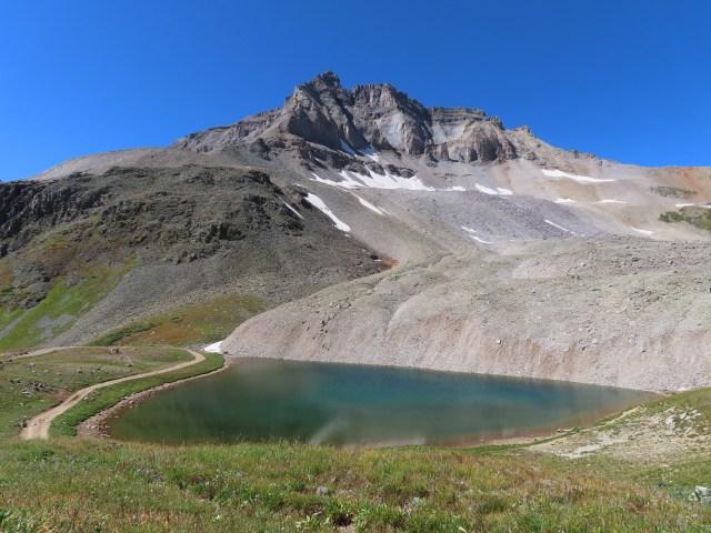
At the top we were at an elevation of 12,400 feet. There was a hike up to Mount Sneffels. The elevation still keeps us from hiking as we really would like.
The blue alpine lake below
was crystal clear.
The more we do this the more addictive it becomes…the more we see, the more we want to see!
We rested for awhile this afternoon and then we went back into Ouray.
We ate at Red Mountain Brewing…yummy food!
Did you notice all of the Jeeps in front of the restaurant??? This is a Jeeping town. There are Jeeps for rent…everywhere and tons of Jeep trails. At least one third of the cars in town are…Jeeps.
After dinner we drove into the countryside looking for elk…no elk.