The RV is backed up to a creek
in this campground. As I lay in bed last
night, I could look through the branches of the ponderosa pine and see the brilliant
light of the moon making the layers of clouds glow. There was a smattering of stars. I could feel the fresh mountain breeze and I could
hear the burbling of the water. I fell
asleep thinking…how lucky am I to live this crazy life with my best friend?
Our adventure today was a Jeep
trail called Yankee Boy Basin. It
started off fairly tame on Camp Bird Road, a graded gravel road.
It was an easy drive along
the ledge with a dramatic rock overhang.
On the way.On the way back.
This was a beautiful ride.
There were vibrant wildflowers of every color.
Our breakfast spot was at
11,150 feet. Boiled eggs and honey wheat
bread with orange marmalade never tasted so good!
There were lots of
waterfalls.
Once we passed the tree line,
we were in the alpine tundra. The air
was crisp and cool at 57 degrees.
There were great patches of
snow.
There were the remnants of
lots of mining activity…open wounds on the mountainside.
There was a gate with a sign
that stated:
This according to the book,
is the best and most adventurous part of the ride!
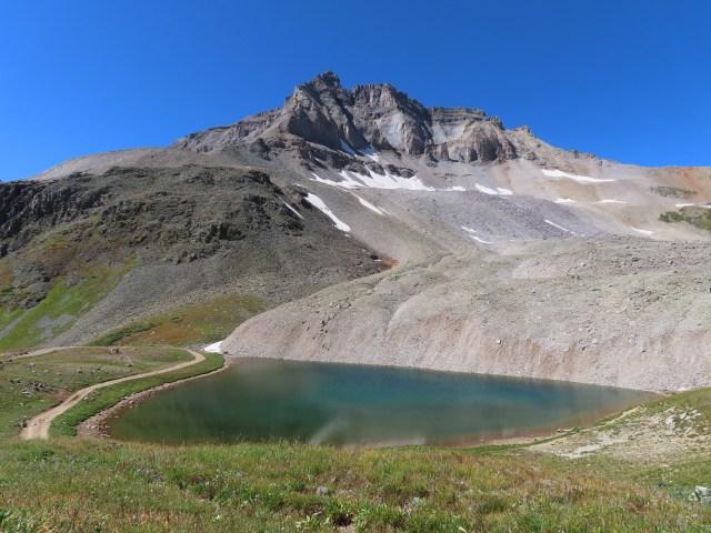
At the top we were at an elevation of 12,400 feet. There was a hike up to Mount Sneffels. The elevation still keeps us from hiking as we really would like.
The blue alpine lake below
was crystal clear.
The more we do this the more addictive it becomes…the more we see, the more we want to see!
We rested for awhile this afternoon and then we went back into Ouray.
We ate at Red Mountain Brewing…yummy food!
Did you notice all of the Jeeps in front of the restaurant??? This is a Jeeping town. There are Jeeps for rent…everywhere and tons of Jeep trails. At least one third of the cars in town are…Jeeps.
After dinner we drove into the countryside looking for elk…no elk.
Our first stop was Montrose. We needed some supplies and we needed WiFi/cell service so that we could make a plan. The area around Ouray has a lot of Jeep trails and lots of other things to see and do. We decided to find a private campground with hookups and WiFi and make that our home base for the next several days. The ride from Montrose to Ouray was really pretty.
Just as we finished setting
up, a light rain began. It rained gently
for the rest of the afternoon. Tim
watched NASCAR and I did some cleaning.
When the sun came out, I went to walk around the campground and I took
some pictures.
Later this afternoon, we drove the Jeep into the town of Ouray. The town of Ouray is known as the “Switzerland of America.”
We went to see the Box Canon Falls. A little chipmunk to greet us.
We walked up the easy path to
see the falls.
Next we took the path to the high bridge. The views of the town snuggled in between the imposing San Juan Mountains was very cozy!
We began the day with an easy
drive south to the Black Canyon of the Gunnison National Park.
We were able to get a campsite
at the South Rim Campground in the park.
It is a no hookup site and no generators are allowed here, so we will
not be able to stay more than one night where we are.
We packed food in the cooler and headed out to explore the park. This canyon is not like other places we have been. Here the canyon was carved by the power of the Gunnison River. The canyon is dark, jagged, and severe but also lovely. The Gunnison River wends its way through the ragged rocks far below. Most of the canyon is about 2,000 feet deep. The pictures really do not do a good job of conveying the beauty and expansiveness of this place. This canyon dwarfed us and made us feel very tiny. The pictures are just pieces of a very large puzzle.
We did a couple of short
hikes today. We are up around 8,000
feet. We would like to get out and do
more hiking but with the thinner air at these higher elevations…we
struggle! Our first walk was to Devil’s
Overlook.
More puzzle pieces…
Our second hike was along the
Warner Nature Walk.
We traveled the park road to
the end and then decided to take the East Portal Road down into the canyon to
the Gunnison River.
More spectacular views.
The Gunnison River was diverted under the mountain in a 6 mile tunnel to the farmland on the other side of the mountain. The tunnel was built early in the 1900’s to provide water for the surrounding valley. This project was later deemed an engineering marvel and given a national civil engineering award.
We made southwestern chicken salad for our dinner. We sat listening to music, by the fire, watching the stars come out. The half moon was so bright that it cast a shadow. We feel closer to the sky but still infinitesimally small…
Day 2 Junction West RV Park Grand
Junction, Colorado
We decided it was time to get
a camera in the hopes that downloading pictures directly to the laptop would
help with the blog writing process. We
were at Best Buy when they opened this morning.
Matt was amazing! He was able to
guide us with our purchase and in addition he helped us gather everything we
needed and then showed us how to set up the camera and how we would go about
downloading pictures at the end of the day.
We drove with our picnic
lunch to Colorado National Monument. We took
the Rim Rock Drive through the park.
There is a learning curve to using any new technology, so unfortunately
the pictures I took of the bighorn sheep right at the entrance were not really
pictures at all…live to learn!! We did
enjoy magnificent views of the canyon.
Our lunch spot today.
Not far from the park there is a Jeep trail called Windmill Loop.
At first the scenery was pretty rugged and scrubby…especially after the beautiful drive this morning.
As we got closer to the Gunnison River, it was prettier. There were some fairly difficult and steep sections along the ledge as we descended and again as we ascended.
The windmill for which the
trail is named actually works.
We had been on the road for 6 hours when we got to the truly difficult portion of the trail.
There are explicit warnings not to try the trail if it is wet. It was 99 degrees, hot and sunny as we started out. The thunder did not begin until we over the most treacherous obstacles. The trail became slick. There are many spots that are covered with bentonite soil. This is a clay like substance that is very creamy and slippery as we quickly discovered when the rain began to fall. We could feel the tires sliding on the greasy surface. The rain looked awesome though. It was coming from one patch of grey clouds. The raindrops were shimmering in the sunlight…very cool!
At last, we made it to the
parking lot.
Bison burgers on the grill
with cucumber salad and sangria…of course!
The pictures we took today
downloaded quickly! Progress has been
made!
Mileage: 67,403 Junction West RV Park Grand Junction,
Colorado
We were sad to leave
Redstone. It is a sweet little town and
the surrounding area was great for exploring.
As we wound our way up the mountain,
we could see into the valley below. Our
campsite was nestled down in there somewhere!
The landscape changed after
we went though McClure Pass and over the Rocky Mountains. The land began to open up again with farms
and ranches.
One of the cool things about
the way we travel is running into little unexpected treasures. We went into Farm Runners Station in
Hotchkiss and found excellent savory breakfast burritos and strong iced
coffee. We also bought some fresh
tomatoes and corn and melon.
As we approached Grand
Junction, we were in high desert. Mesas
and mountains surrounded us.
We saw this guy with a trailer pulled over with a flat. Tim stopped to see if he could help. The man had already called for roadside assistance. It was his third flat of the trip.
We needed a full-service
campground. We had dusty laundry and
lots of blog to catch up on. We chose
the Junction West RV Park.
I gathered stuff and headed
to the laundromat. I had planned to use
the park WiFi to publish and post pictures.
In the almost two hours it took to get the laundry done, I had only
uploaded one picture…and I had tons…I did publish the blog without pictures,
but that just isn’t the same. We have
debated giving up on the blog, but I love the idea of having this living journal.
Since leaving Atlanta, the
WiFi on the laptop has not been functioning.
I was able to use my phone as a hotspot with an ethernet cable. This proved to be an aggravating solution because
the internet speed slowed so badly, but it was all I had and we had been
coaxing it along and making it work.
After a couple of hours of trying, I decided that since we were in a big
town, I would try to come up with an alternate solution. I ended up at Office Depot where a young man
named Casey helped to run diagnostics on the computer. It turned out that the internet card is
damaged. I could leave it for a couple
of weeks for service or I could purchase a High Gain Wireless Dual Band USB
Adapter. Casey helped me chose one and
even installed it on the computer using store internet.
I got back to the campground
and because the signal was so weak…I made limited progress. I worked until 5:30.
We went downtown to the Thursday Farmers Market. Main Street is blocked off. There were two music venues, lots of local produce and other crafts and wares. For dinner we went to the pink food truck and had figgy goat salads. We sat at a little table enjoying the cooler evening air and the music and atmosphere.
The Bookcliff Barbershop Harmony Chorus. They were good and great fun to listen too!!
Day 2 Redstone Campground
White River National Forest Carbondale, Colorado
I was awake early. I enjoyed my morning coffee and was watching
for the momma bear and her cubs. Instead,
I watched a red fox sniffing around at a campsite across the road. It was too far away for a good picture. He explored the bear box and the fire ring
and finding nothing to eat, he slunk off into the brush.
Today we planned to take the
Lead King Basin Trail. We have this
really neat book that lists many of the trails.
We set out at 8:30 this
morning with our picnic lunch packed. We
had no idea what kind of adventure awaited us!
We had to access the
beginning of the trail in the town of Marble.
This town is aptly named. There
is a marble quarry here where pure white marble is cut. The marble here was used on the Lincoln
Memorial in Washington DC and the Tomb of the Unknown Soldier in Arlington.
We passed Beaver Lake and our
journey was underway!
At the start of the trail
there were these signs posted…2 ½ miles into the trail was an area of extensive
avalanche damage.
We decided to go and take a look. The ride was lovely.
There is all kinds of bear food along the way. Ripe raspberries, rose-hips, red, yellow, orange and purple berries, and lots of chipmunks!
Locals call the aspen trees “quakies”. They are actually Quaking Aspens. Today with the breeze blowing you could see the silvery leaves fluttering and well…quaking!
We arrived at the site of the avalanche and we were overwhelmed by the amount of damage we saw. An enormous amount of snow came from very high on the mountain and toppled everything in its path. The pine trees lay in a tangled pile like pickup sticks. The Forest Service had cut a path through…a winch might be necessary!
Much of the debris lay on several feet of compacted snow!
While Tim evaluated the trail
ahead, I took pictures of the wildflowers.
Tim decided that he would
like to try to get through the minefield of logs. It started out ok and then it got harder…a
lot harder!!
There were all manner of
pieces of tree in the way. Tim used a
handsaw to clear part of it. He drove up
onto the log pile and there was a log jammed against the back wheel. There really was not a good way to go
backward…it was too late. We were
committed. The only way was
forward. This is where our new winch
came in handy…Kyle…we really could have used you here!!
We were able to winch the
Jeep forward and then we were still stuck!
Tim came up with an idea to double back on the winch to help move a huge
log out of the way. This actually worked…at
last we were free!! I was standing
outside directing Tim and operating the winch.
It was a little nerve-wracking but it was also fun to work together to
make a plan and figure our way out. When
the Jeep at last was free and moving up the hill I was elated and I know I yelled
out loud!
The area after the avalanche
was much easier to traverse and the scenery was beautiful. We traveled up the mountain on switchbacks and were treated to an aerial
view of the damage from above…WOW!!!
We found the perfect lunch
spot with 360-degree views…spectacular!!!
The blue sky, the mountains, the wildflowers, the waterfall, the patchy
snow…
We were in Lead King Basin at
10,240 feet.
What we didn’t realize is
that this trail dumped us onto the Devil’s Punchbowl Trail. This Trail had an extremely high difficulty
rating and is in fact very dangerous, several fatalities have occurred here. We wouldn’t have chosen to ride on this trail
but now our options were limited. We
certainly did not want to go back through the avalanche site.
Fortunately, Tim is a very careful
and good driver. Slowly we made our way
up the incline and along the shelf with steep drop-offs. We didn’t stop to take
pictures because it was not okay to do so.
We were very grateful to come the part of the trail that was “the easy
road through a scenic valley!”
We drove through Schofield
Pass at 10,717 feet.
Past Emerald Lake…
Over a snow obstacle…yes snow!!
Finally, we arrived on smooth
pavement in the town of Crested Butte.
We stopped for fuel and directions.
We were able to take Route 12,
Kebeler’s Pass a partially paved and partially graded but maintained road back
the 60 miles to the campground. I drove
this part. We stopped once to enjoy the
view.
We left at 8:30 and returned
at 5:30. We decided to go back to the Redstone Inn for dinner. We were so terribly dusty and dirty from our adventure…that
we showered first. Tonight, we actually
each had 2 drinks! We were waiting for
pictures to load for the blog, borrowing the Inn’s internet and so we even
shared Bananas Foster for dessert!
Today was long but it was a
very good day…we were able to work together to negotiate a tricky trail and we
were rewarded by the gorgeous pictures that few other people get lucky enough
to take!
Mileage: 67, 284
Redstone Campground White River National Forest Carbondale, Colorado
Please pardon us if there are
not pictures posted with the blog each day.
Yesterday it took hours and hours to post the blog. We have decided that we will try to post the
journal every day that we have enough cell service. We will add the pictures and catch up
whenever we have better service…it will be much less frustrating that way!
We stopped along the Arkansas
River for our breakfast.
The mountains over 14,000
feet are still garnished with patches of snow.
It is September and it won’t be long before the snow begins to fall
again here.
Tim was getting a slight headache
traveling at the higher elevations but it was better with ibuprofen and fluids. We also took lots of breaks which gave me
lots of opportunities to take pictures.
We passed over the
Continental Divide at an elevation of 10,424 feet at the Tennessee Pass.
Today was a gorgeous ride on
a curvy and winding road with occasional steep grade.
We are always scanning the boggy areas and ponds for moose and looking for bighorn sheep in the rock outcroppings. We did see lots of ravens and magpies and an osprey scouting the river.
We passed through the town of
Minturn, a pretty mountain town with big bright baskets of flowers and log
cabins built along the riverside.
It was our intent to travel
north of Salida through Buena Vista and on to Aspen. There was a sign posted shortly before our
turn that stated that no vehicles longer than 35 feet were permitted on Route
82. The RV is 35 feet and then we tow
the Jeep behind us.
We decided to forgo that
route and we continued north on 24 to Interstate 70…ugh an interstate! If we turned and headed east on 70 we would
arrive at the Baltimore Beltway in about 1611 miles!
This portion though of 70 is
an amazing ride! There was a rest area
beside a small lake.
The drive through Glennwood
Canyon had outstanding views.
There was an extraordinary
rest stop…like no other…on the Colorado River.
We have been on a lot of
really beautiful drives…this ranks right at the top.
From 70 we accessed Route 82
and headed south to Redstone Campground.
We have a site with a view of the mountains along the Crystal
River.
There are active bears in the
area. Each morning, a mother bear and
her cubs make their way down to the river across the campground. Hopefully we will get to see them!
The Redstone coke ovens were built in 1899. Here impurities were burned out of coal. The coke was used to create steel for the railroads.
This evening we went
exploring in the Jeep. We took the road
up to McClure Pass.
All along I have been
thinking that the trees with white bark are birch trees…but they are quaking
aspens. The leaves are just starting to
turn in some places to a limey green…it won’t be long before they are golden.
We found the Redstone Inn for dinner and enjoyed a delicious meal.
The skies are slightly cloudy this evening as we work on the blog but it is pleasant enough to be sitting outside.
Tim is feeling much better but we decided to stay here one more day.
We took our bikes into the historic district of Salida. It was a nice place to cycle. Salida is just what you might imagine a small mountain town in Colorado would look like. Tall peaks surround the town.
There are all kinds of lovely small shops, lots of parks and green space, and families were out and about.
We rode along the streets of
town and along the river’s edge. There
were people enjoying the water.
There are lots of interesting sculptures adorning the roads.
The air in Colorado is fresh and clean smelling. Here lavender is planted in most of the planters and gardens in town. You can catch the aroma as you pass by.
There was a Natural Grocers store and we went in and decided to come back with the Jeep to get some nice produce, organic chicken, and bison. We took our groceries to the RV and went back into town for lunch. We had delicious food at Mo Burrito.
After getting a couple of other supplies at Walmart and filling the Jeep with gas, we returned to the campground for a quiet afternoon. It is warm but there is a breeze and sitting in the shade is pleasant.
Grilled apple chicken sausage and veggie skewers with grilled pineapple for dinner…yum!
Mileage: 67,103 Four Seasons RV Park Salida, Colorado
Tim didn’t feel well. It started yesterday with a headache. We had both been experiencing some mild shortness of breath with any kind of exertion. We knew that was because of the altitude changes. I was doing better but Tim was not. We had spent Wednesday and Thursday riding on trails at about 8,000 feet. Friday, we went to the Continental Divide above 12,000 feet and then slept in a tent at close to 12,000 feet. It took us 3 hours to come back to the RV yesterday and it was clear that Tim was not feeling well. He had a headache and a sore neck. Later in the day he had persistent shortness of breath, fatigue, and a dry cough.
Today when he woke up, he had
a bloody nose and felt awful. We did
some research and realized that these were effects of mild altitude
sickness. We decided to move away from
our free but very dusty campsite, hopefully to a lower elevation.
We traveled to the Poncha
Springs Visitor Center to empty tanks and get fresh water. Our original plan was to drive to Aspen but
Tim was in no condition to drive that far and it is at a higher altitude. Tim didn’t feel as sharp as usual and I was
concerned that his lack of decisiveness might be confusion. We found a campground in Salida at a lower
altitude. Tim already feels better.
We have learned that even if
you visit a higher altitude during the day, you should return to a lower altitude
to sleep. We have also learned that
fluids and ibuprofen can be helpful in managing symptoms. Altitude sickness can become severe. Significant shortness of breath and confusion
are reasons for medical treatment.
Fortunately, we have a plan. We
are going to stay at 7,000 feet and get more acclimated before we travel back
into higher altitudes. We got so excited
by all there is to see and do that we didn’t even consider the possible ill
effects. We are smarter now! Tim is determined to go back…he’s NOT giving
up!
Meanwhile, we have had a restful day catching up with some small chores and relaxing by the river.
I made Cowboy Caviar for our lunch today. I used a recipe from Dana. I had to modify it slightly because of the ingredients I had on hand. I used apple cider vinegar and pinto beans…it was delicious!
Tim was hoping to watch the NASCAR race but it was pouring rain in Darlington, SC. The rain delay was 3 1/2 hours. He started watching the race at 7:30. At 7:30 there was live music in the campground. I went to listen for a while. The guy could sing!
We were awakened at 6:30 by the chattering of squirrels whose nest was in the tree above the tent. We made coffee and slowly gathered all of our gear. By 7:30 we were on our way to the tiny mining town of Tincup. We saw a couple of white tailed deer and a mule deer and lots of chipmunks…they are everywhere! It was a beautiful early morning ride. From Mirror Lake to Tincup the road is hardpacked gravel.
Twenty miles on gravel road to Pitkin, another small mining town.
Here the pavement begins.
Finally we were on the highway! Another 63 miles to get to the RV!
We stopped in Poncha Springs to get groceries. We spent the afternoon unpacking and recovering from our overnight adventure. This evening I drove to Salida to the closest Laundromat. On the way, I passed a couple of full-grown does and their fawns right in town. As I was folding clothes, this buck walked across the parking lot and out into the road.
We cooked salmon and Mexican street corn on the grill. Tonight we are tired!